
 Flash News
Foreign exchange, the rate at which foreign currencies are sold and bought
Clear skies throughout Albania, here's what the weather is expected to be like today
Conflict between young people in Fushë-Krujë, 22-year-old injured with knife
Kanye West's state-funded concert, OCCRP: Government accused of using the concert to stifle protests
Here are the years of imprisonment requested for Monika's mother
Drought and flooding, scientists warn of the strongest El Niño in 140 years

Politiko
2026-06-19 09:44:28
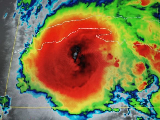
A potentially extreme El Niño, a climate phenomenon that could affect weather patterns around the world in the coming weeks, is developing in the Pacific Ocean. Meteorologists are warning that it could be the strongest El Niño on record.
The phenomenon has "real potential to develop into the strongest El Niño activity of the last 140 years," says Paul Roundy, professor of atmospheric and environmental studies at the State University of New York (Albany).
The World Meteorological Organization (WMO) predicts that El Niño weather conditions will soon begin to be felt and will last at least until winter. Depending on the strength and duration of the phenomenon, it could lead to droughts, floods, heat waves and disruptions to food and water supplies in many regions.
What is El Niño?
El Niño is a natural climate pattern that occurs every two to seven years. It begins with a weakening of the trade winds over the tropical Pacific. As a result, warm waters accumulate in the Pacific Ocean.
This warming is happening in just one region, about the size of the United States, but the effects are felt across the globe. "Changes in the tropical atmosphere can also affect the atmosphere in the mid-latitudes," says Gavin Schmidt of NASA's Goddard Institute for Space Studies. "So it affects us, even though we may be thousands of miles away."
A global chain reaction is created, with El Niño being the first "atmospheric domino to fall."
What are the expected effects on the climate?
The effects of El Niño vary greatly from region to region. In some countries it causes drought, while in others it causes flooding. Some regions in Central America, Asia, Africa and Australia become hotter and drier during El Niño years. Water shortages affect agriculture, hydroelectric power generation and drinking water supplies. In Honduras, authorities expect severe drought to affect about 75 municipalities. A water emergency has already been declared in the capital, Tegucigalpa.
In other regions, the opposite happens. In parts of the Pacific coast of South America, El Niño can cause torrential rainfall and devastating flooding.
Even after rainfall has stopped or reservoirs have dried up, the effects can be felt for a long time. El Niño is associated with crop losses and economic damage in the trillions. During the 2015/2016 El Niño, millions of people around the world needed food aid due to poor harvests.
Forest fires are also becoming a growing threat. Scientists warn of an increased risk of extreme heat and drought, which are fueling fires in Australia, Canada, the US and the Amazon rainforest.
Storms, corals and hurricane season
El Niño also plays a role in the formation of tropical storms. Scientists expect this year's Atlantic hurricane season to be weaker than usual. The phenomenon typically increases wind shear over the Atlantic, making it more difficult for storms to form and strengthen.
"In the tropical Pacific, the waters are warming," explains scientist Brian Tang. "When El Niño develops, especially during hurricane season, the formation of clouds, storms and rainfall in the Atlantic is usually inhibited."
However, fewer storms does not mean less danger. If a storm becomes a hurricane, it is difficult to stop and can cause catastrophic damage.
In the Pacific, the opposite happens: El Niño usually causes more and stronger storms.
Marine ecosystems are also under pressure. Higher water temperatures could cause coral bleaching and further damage coral reefs already weakened by climate change.
Farmers are also feeling the effects. In India, mango growers reported significant declines in production due to unusual weather conditions that affected flowering and fruiting.
How does climate change affect?
According to scientists, there is no clear evidence that climate change itself strengthens El Niño, but it may increase its effects.
"A severe drought caused by could turn into an extreme drought due to climate change," says Michael McPhaden.
Warmer air holds more moisture, increasing the risk of extreme rainfall and flooding. Higher temperatures also worsen droughts, as the soil dries out more quickly.
With global temperatures already near record levels, El Niño could push them even higher.
How can the world prepare?
One advantage of El Niño is that it develops slowly and can be observed months in advance. Scientists monitor ocean temperatures and atmospheric conditions, giving governments and communities time to prepare.
Forecasts enable authorities to take measures to protect crops, improve flood protection, and optimize early warning systems.
"We know where there will be more rain or unusual drought," says McPhaden. "Thanks to long-term forecasts, we have enough time to develop strategies to limit damage and avoid the most severe consequences."/DW
Latest news


Speaking multiple languages can keep your brain up to 13 years younger
2026-07-14 09:35:11
Strait of Hormuz becomes key battleground again, oil prices rise
2026-07-14 09:20:09

73.4% of Albanians' out-of-pocket health expenses go to medicines
2026-07-14 09:02:28
Over 10,000 dead from extreme heat wave in Europe, elderly most affected
2026-07-14 08:59:36

Foreign exchange, the rate at which foreign currencies are sold and bought
2026-07-14 08:24:50
The ten challenges Spain must win to eliminate France and Mbappé
2026-07-14 08:04:02


Morning Post/ In 2 lines: What mattered yesterday in Albania
2026-07-14 07:00:35
Ukraine strengthens air defense, Macron announces deal for 16 Rafale jets
2026-07-13 22:26:00
Shkullaku: Qeveria përdori koncertin e Kanye West për të eklipsuar protestën
2026-07-13 22:11:36
Conflict between young people in Fushë-Krujë, 22-year-old injured with knife
2026-07-13 21:47:26


Haaland, the phenomenon of the 2026 World Cup
2026-07-13 20:19:12
Citizens take to the streets again, protest enters 44th day
2026-07-13 20:01:25
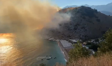
Large fire in Himara, flames engulf the hills of the Llaman area
2026-07-13 19:28:11


Dutch referee dies, weeks after being banned from 2026 World Cup
2026-07-13 18:22:39

What professions make people the happiest?
2026-07-13 17:51:54


Brazil still in crisis, fans attack Federation after motivational video
2026-07-13 16:42:07
The Special Court returns the file against former mayor Elvis Roshi to SPAK
2026-07-13 16:22:11
IDC-CDI meets in Brussels, Berisha participates as Vice President
2026-07-13 16:05:10
"Washington Examiner": Anger against Rama's enrichment has reached its peak
2026-07-13 14:28:00
Here are the years of imprisonment requested for Monika's mother
2026-07-13 14:09:46
EU appoints German diplomat as new special envoy for Kosovo
2026-07-13 13:55:29


Property alienation in Durrës/ Court confirms security measures for suspects
2026-07-13 13:25:00
70 people with poisoning symptoms in Pristina, 22 hospitalized
2026-07-13 13:16:00


Erkin Lika's lifeless body found after falling into Mat River sinkhole
2026-07-13 12:32:00
Over 500 babies named after Haaland after World Cup matches
2026-07-13 12:28:00
18 arrested in Spain, who is the Albanian known as 'Daci'?
2026-07-13 12:22:00

4.2 million euros for Kanye West, DP reports Rama and Gonxha to SPAK
2026-07-13 11:27:03


Heatwave hits Germany, over 5,400 heat-related deaths
2026-07-10 10:45:33

Land in "foreign hands"
2026-07-10 10:26:15

Mbappe the hero of France, the "Roosters" knock out Morocco in the quarterfinals
2026-07-10 09:54:33
Durrës/ 40-year-old man stabs his wife
2026-07-10 09:48:03


How much could the amount of drug money in the Albanian economy be?!
2026-07-10 09:08:34
Government reduces funds for farmers, increases ADF by 75 million euros
2026-07-10 08:55:46
Horoscope, get to know the star forecast
2026-07-10 08:32:54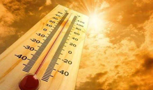


Morning Post/ In 2 lines: What mattered yesterday in Albania
2026-07-10 07:52:04
A person was shot dead in Kurbin, first details
2026-07-09 22:54:48


Will the Police also stop those who criticize Rama online?
2026-07-09 21:57:02


FIFA decision shocks England, Quansah ruled out for two matches
2026-07-09 20:51:00


Protest/Pedagogue: 4 million euros for Kanye West is "the next concession"
2026-07-09 19:45:53
French MEP joins protests in Albania: Support for the "Pink Flamingo Revolution"
2026-07-09 19:28:07


Has the lek strengthened or overvalued?
2026-07-09 17:58:05


The trial on the merits for Ilir Meta and Monika Kryemadhi is postponed
2026-07-09 16:47:58

The match between England and Norway risks being postponed, this is the reason
2026-07-09 16:12:46
Murder in Shkodra/ Relatives: Peaceful family, no problems
2026-07-09 16:10:02
Kurti invites opposition leaders to a meeting to create new institutions
2026-07-09 15:43:05